数据共享平台

全球海平面重建数据
Global Sea Level Reconstruction Product
» Description
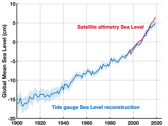
This dataset provides global mean sea level and regional sea level reconstructions derived from tide gauge records and satellite altimetry observations. It represents an improved version of the reconstruction by Church and White (2011), utilizing a reduced-space optimal interpolation technique. Enhancements include the incorporation of sea level fingerprints, sterodynamic sea level change patterns, and more comprehensive estimates of local vertical land motion.
» Essential information
Time Range: 1900/01-2019/12
Resolution: 1°
Region: global
Longitude Range: 0°~360°E
Lat Range: 65°S~65°N
Temporal Resolution: annual
Storage Format: NetCDF / ASCII
Elements: Sea level
» Data Download

» Data Producer
Jinping Wang, John Church, Xuebin Zhang, Xianyao Chen
» Data Contact
wangjinping@ouc.edu.cn
» Data Usage Statement
Content: In order to protect the rights and interests of data producers and data service provider, please mark data sources and cite the literature references according to the citation statement.
Reference: Improved Sea Level Reconstruction from 1900 to 2019. Jinping Wang, John Church, Xuebin Zhang, and Xianyao Chen. Journal of Climate, 2024. https://doi.org/10.1175/JCLI-D-23-0410.1